Share instagram

MT ULAP TOUR

Mt. Ulap

Trek

A Walk in the Clouds


TRIPinas offers you an array of options for your Mt. Ulap tour packages — joiner, private, or DIY. You can go for a day hike if you’re pressed for time or sign up for an overnight tour to star gaze and catch the sunrise the following day. With strategic pick-up points from Metro Manila or Baguio city, you can be sure that our trips are safe, reliable, organized, and budget-friendly. Backed by 10+ years of TRIPinas experience, we make sure your mountain escape is smooth and worry-free so you can focus on the trail and the view.

MT ULAP TOUR PACKAGES 2025 & 2026

hiking Mt. Ulap

● PACKAGE DETAILS ●

Rate starts at PHP1500 (Manila)
or PHP750 (DIY style)

INCLUDED:
✔ Round-trip air conditioned transportation
✔ Service of a driver, gas, toll and parking fees
✔ Tour guide for the trek
✔ All the permits
✔ All the fees

● MT ULAP ITINERARY ●

DAY TRIP
Departure is at 0030AM from Manila and 530AM from Baguio
630AM Base camp -Start hiking
9AM at Gungal Rock (1814 masl)
1030AM at Mt. Ulap summit (1846 masl)
2PM Back at the base
Arrival in Baguio at 330PM and Manila at 10PM
WE ALSO OFFER OVERNIGHT TRIPS!

● PACKAGE 101 ●

Available: Everyday
Difficulty level: Easy/Beginners
Tour type: Joiners or Exclusive
Requirements: None


Inquire now


PICTURE

PERFECT

WHAT TO EXPECT WITH OUR MT ULAP HIKE?


If you have signed up for a private day tour, you’ll be picked up from a pre-agreed location — around midnight if coming from Metro Manila, or around 5 AM if coming from Baguio City. For joiners day tour, your pick-up time and point (usually starting around 10 PM for the first pick-up) will be clearly indicated in your confirmation email. There will be a quick breakfast stop in Baguio city before proceeding to the registration site at Brgy. Ampucao in Itogon where your dedicated guide will be waiting for you.

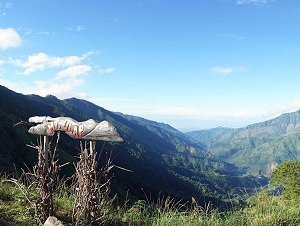
After some introduction and a few reminders on climbing etiquette, you will commence your hike starting at Tomtombek. Brace yourself for a steep walk up to the first view deck. Once at the view deck, give yourself some time to take in the sights before continuing your trek. For the most part, the walk will be on a pine tree-lined trail, naturally decorated by purple-colored melastomas, sunflowers and wild raspberries (sapinit). Every now and then, you will cross some wooden gates that were meant to contain cows that roam around freely in the mountain. The landscape is so pretty that before you know it, you already have Ambanao Paoay aka Peak 1 (1788 masl). Continuing from here, you will reach Gungal or Peak 2 (1814 masl), arguably the most photographed* spot in Mount Ulap. Walking for another kilometer from Gungal, you will reach the peak of Mt. Ulap (1846 masl). Take note of the pitcher plants growing close to the old border stone. Visibility here varies widely - one minute you have a sweeping view of Baguio City, then a few moments after you are enveloped in a thick fog you can hardly see anything. From this point, hiking will be all downhill (literally). Take extra care when going down especially when the visibility is poor. You don't want to bump into a grazing cow. You can have your lunch break at one of the make-shift carinderias before you continue your 2-km descent. After about an hour, you will finish your traverse and exit at Sitio Sta. Fe where your return vehicle awaits. You may use the toilet facility at the exit to freshen up before you board your land transfer and return to Baguio. Once there, feel free to have a celebratory dinner before heading back to Manila. If you opted to camp overnight, departure from Manila or Baguio City can be scheduled much later. Tents are included in the package, and your guide will assist you in setting them up. You are most welcome to bring your cook set to prepare your meals, or you can buy cooked food from the eateries near the campsite.

FAQ


Where is Mount Ulap located?

This mountain is located one hour away from Baguio city in the Cordillera range, north of the Philippines

How long is the hike to Mount Ulap?

Mount Ulap eco-trail is a 9.21km hiking path located at the Ampucao - Sta. Fe ridge in Itogon, Benguet. A moderately fit person can finish the traverse in about 5 hours.

What’s the difficulty level?

It is considered easy and beginner-friendly

Are guides mandatory?

Yes, tour guides are required. It is forbidden to hike the area unguided.

When is the best time to go?

We suggest visiting during the dry months from November to May. As the trail is exposed, start your hike as early as possible.

What should I bring for the hike? What do I wear?

Bring a 25–30L day pack with a rain cover, at least 2 liters of water or hydration, and some trail food or snacks to keep your energy up. Don’t forget your rain gear or poncho, sun protection like a wide-brimmed hat. Wear a moisture-wicking, sweat-resistant top (avoid cotton shirts). A walking stick, trash bags, and a headlamp (for overnight tours) will also come in handy. Lastly, pack your hiking sandals or shoes, a change of clothes with basic toiletries, and extra cash for miscellaneous expenses.

How crowded does it get?

It can get crowded on weekends and summer months. If you can afford it, go on weekdays and holidays.

What’s there to see?

Mt. Ulap offers breathtaking views of the Cordillera mountain range, rolling grasslands, and scenic pine ridges. Along the trail, hikers pass through Ambanao Paoay, the famous Gungal Rock, and finally reach Mt. Ulap summit with its sweeping mountain and valley views. On clear days, you can even spot Mt. Pulag in the distance.